
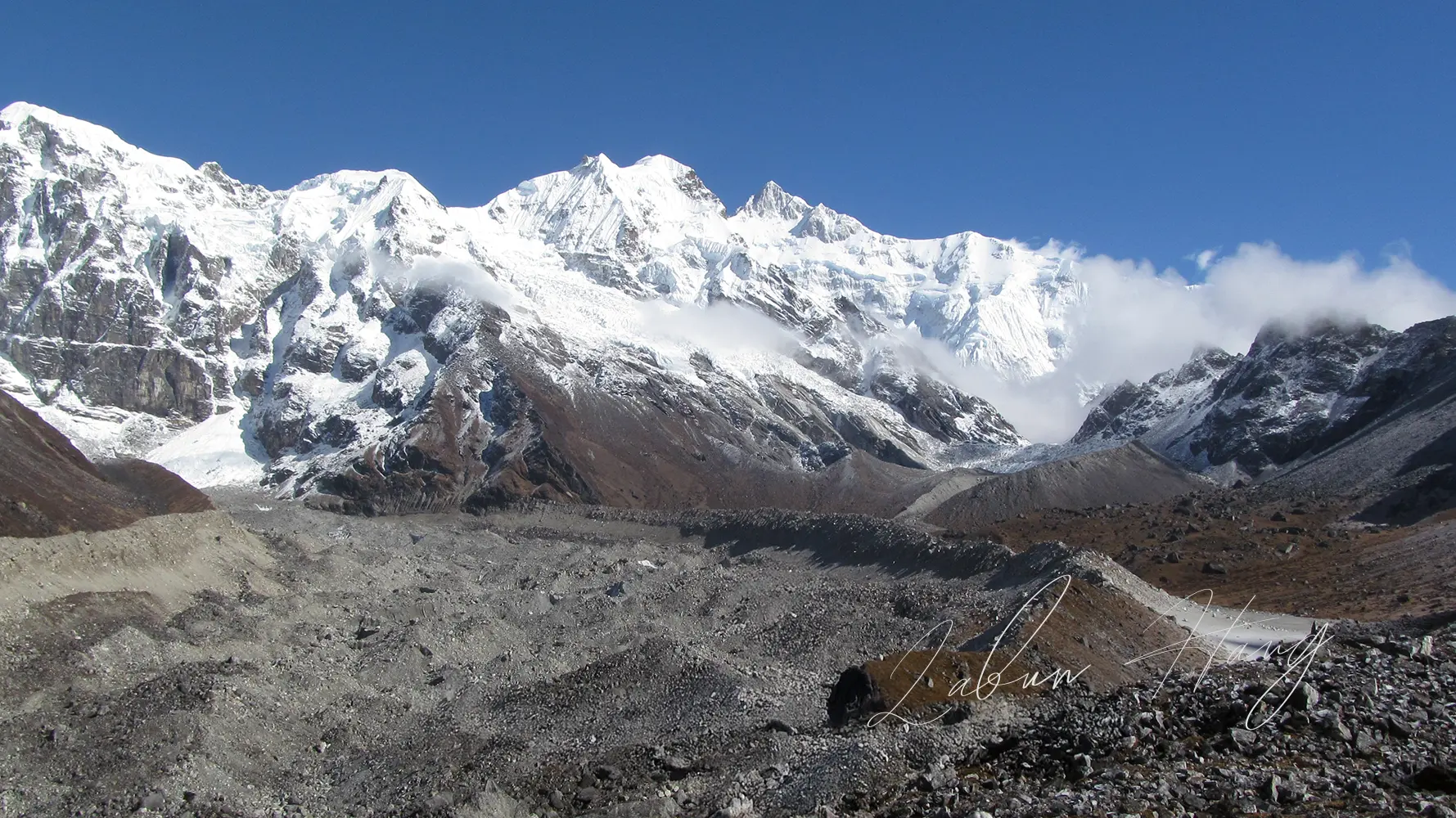
The Goechala Trek begins in Yuksom, climbs through the forests and high meadows of Khangchendzonga National Park, and reaches a mountain viewpoint at roughly 4,600 metres (15,100 feet). Its greatest reward is the close view of the Kanchenjunga massif, with Mount Pandim, Kabru and other Himalayan peaks filling the skyline. Most trekkers follow a route through Tshoka, Dzongri, Thansing and Samiti Lake before turning back from Goechala Viewpoint 1.
The name can be misleading. Goecha La is a mountain pass at about 4,940 metres, but the pass itself is not the normal permitted destination for recreational trekking. Current itineraries end at Viewpoint 1. The difference matters when you compare route maps, advertised heights and photographs.
I grew up in Yuksom, where the trek begins. From here, Goechala is not simply a distant peak on a tour brochure. It is part of the larger mountain landscape that shapes local life. This guide explains how the trail works, what the walking days are really like, and what to settle before you travel.
Goechala Trek at a Glance
- Walking distance
- 73–90 kmApproximate round-trip range; route dependent
- Difficulty
- DifficultHigh-altitude walking; normally non-technical
- Preferred seasons
- Apr–May / Oct–NovSpring flowers and post-monsoon mountain views
- Stay and access
- CampingYuksom guesthouses; park permits required
How high does the Goechala Trek climb?
Approximate height above sea level
The bars show elevation above sea level, not total ascent or the climb on any single day.
Goechala Trek route from Yuksom
- Yuksom
- Sachen
- Tshoka
- Phedang
- Dzongri
- Kokchurung
- Thansing
- Lamuney
- Samiti Lake
- Viewpoint 1
The return follows the upper valley to Kokchurung, then the traverse toward Phedang and Tshoka before descending to Yuksom.
Viewpoint 1 is not Goecha La Pass. The geographical pass is higher, at approximately 4,940 m, and is not the normal permitted endpoint for trekkers.
Altitude and distance figures are approximate. Camps can be positioned differently, while trail trackers and tour operators count mileage in different ways. A responsible itinerary matters more than a suspiciously exact total.
Why the Goechala Trek Is Worth the Journey
The appeal begins well before the final viewpoint. On the first days, the route stays beneath thick forest. Trees block much of the sky, roots and damp earth keep your attention on the path, and the sound of water is often closer than the mountain views. Higher up, the character of the walk changes. Rhododendron forest gives way to the open ground around Dzongri, then to the long valley beneath Pandim.
That gradual change makes the trek memorable. You do not get the same scenery repeated over eight or nine days. You travel through different elevations, temperatures and vegetation, often within the same afternoon.
The mountains appear before you reach Goechala
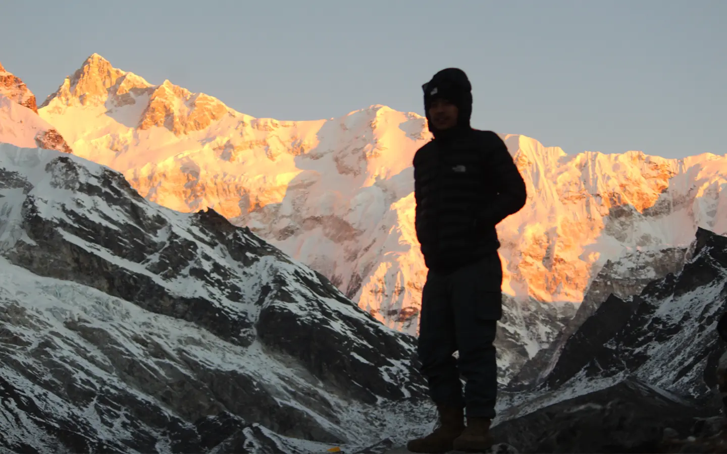
Dzongri Top is one of the most important stops. On a clear morning, it gives a broad view of Kanchenjunga, Kabru, Rathong, Pandim and neighbouring summits. You can see why trekkers who are unable to continue toward Goechala still remember Dzongri as a complete mountain experience.
Thansing changes the scale of the landscape
After the descent from Dzongri to Kokchurung and the climb into the Thansing valley, the forest opens out. The Prek Chu runs through the valley, and Pandim rises sharply above the camping ground. There is a striking difference between looking up at a peak from a dense forest and seeing its whole slope from an open valley.
Samiti Lake is part of the approach, not the finish
Samiti Lake lies above Lamuney on the route toward Viewpoint 1. It is an alpine lake enclosed by higher slopes, and its appearance changes with snow, ice, cloud and the time of day. Do not expect the same bright-blue photograph in every season. More importantly, treat the lake and its shore as part of a protected landscape rather than a place to leave food, packaging or other waste.
Where Does the Goechala Trek Start?
The trail starts from Yuksom, the historic first capital of Sikkim, at approximately 1,780 metres. Most visitors arrive through Bagdogra Airport or New Jalpaiguri railway station, then travel by road through the foothills and into West Sikkim. Allow much of a day for the drive. Road conditions, traffic and the route taken can make a large difference to the journey time.
Yuksom is more than a point of departure. It has homestays, guesthouses, small shops and important historic sites, including Norbugang and Dubdi Monastery. Arriving early gives you time to finish the practical checks and get a proper night’s sleep instead of beginning a demanding trek straight after a long drive. If you have spare time, my Yuksom sightseeing guide separates short local walks from longer road excursions.
Goechala Trek Route and Distance
- Yuksom1,780 m
- Sachen~2,180 m
- BakhimTrail stop
- Tshoka~2,950 m
- Phedang~3,650 m
- Dzongri~4,020 m
- Dzongri La Pass~4,400 m · day hike
- Dzongri Top~4,200 m · sunrise hike
- Kokchurung~3,700 m
- Thansing~3,800–3,950 m
- Lamuney~4,150–4,200 m
- Samiti Lake~4,300 m
- Viewpoint 1~4,600–4,650 m
From Yuksom via Tshoka and Dzongri. The trail then drops to Kokchurung before climbing toward Viewpoint 1.
From Viewpoint 1 back through the upper valley to Kokchurung, then via Phedang and Tshoka to Yuksom.
Schematic trail profile, not a navigation map. Distances and campsite elevations differ across itineraries. Dzongri Top and Dzongri La Pass are separate hikes from Dzongri camp.
The route is sometimes called an out-and-back trek, but that description hides an important detail. The descent from the upper valley uses a traverse linking Kokchurung and Phedang rather than simply retracing the entire ascent through Dzongri. This saves an unnecessary climb back to the higher camp.
Published route totals differ. Indiahikes lists about 73 kilometres, while other trekking operators quote approximately 80 to 90 kilometres. Some include walking to viewpoints and acclimatisation outings, and some use longer or shorter stages between camps. Ask for the daily distances of the exact itinerary you are booking. They are more useful than the headline total.
Goechala Viewpoint 1 or Goecha La Pass?
They are not the same place. Viewpoint 1 is the commonly permitted trekking destination at about 4,600 metres. The geographical pass is higher, near 4,940 metres. Trekking access beyond Viewpoint 1 has been restricted for years, so photographs and descriptions of Viewpoints 2 and 3 or the pass itself may relate to older journeys. Plan around the current permitted endpoint, not an archived itinerary.
Goechala Trek Itinerary: An 11-Day Route
This is an 11-day plan, including travel to and from Yuksom. It gives you a full day at Dzongri to rest and adjust to the altitude, plus a night at Lamuney before the early walk to Viewpoint 1. Some companies finish in ten days by changing their camps or combining stages. Check where you will sleep each night before comparing itineraries.
Distances, walking times and campsite elevations are approximate for this 11-day route. Days 1 and 11 are road journeys, not trekking days. Camps and return routes may vary between operators.
Arrival day
Day 1: Arrive in Yuksom
Travel from Bagdogra, New Jalpaiguri or Siliguri to Yuksom. Most of the day may be spent in the vehicle. Check your equipment, identification documents and permit arrangements before dinner. Make sure everyone knows the next morning’s departure time. If the journey has been delayed, resist the temptation to replace sleep with sightseeing. The first walking day starts early enough.
Forest approach
Day 2: Yuksom to Sachen
The route leaves the settled area and enters forest. Early sections rise and fall rather than climbing in one smooth line. You cross small streams and walk on paths that can be muddy, especially after rain. Wooden bridges and the noise of water below make this stretch feel very different from the exposed country higher up. Sachen is a forest camp, not a mountain-view campsite. Expect the air to be damp and the evenings to cool quickly.
This is a useful day to settle into a pace you can maintain. Fast walking here brings little benefit, particularly when you still have the more serious height gain ahead.
Gaining altitude
Day 3: Sachen to Tshoka via Bakhim
The path continues through forest and climbs more noticeably around Bakhim. In wet conditions, roots, stone steps and slippery earth demand care. The last part toward Tshoka can feel steep after a day of carrying a pack. Tshoka sits around 2,950 to 3,000 metres, much higher than Yuksom, so the change in altitude is no longer theoretical.
The settlement area has old mountain buildings and a small monastery, but facilities for trekkers are basic. This is still camping country. Eat, drink and rest even if the day’s distance seems modest on paper.
Steep ascent
Day 4: Tshoka to Dzongri via Phedang
For many people, this is the defining uphill day. The route climbs through rhododendron woodland on steps and steep sections toward Phedang. In spring, flowers may colour the forest, but the climb remains sustained. Beyond Phedang, the woodland thins, open ground appears, and the air feels markedly cooler.
Dzongri lies close to 4,000 metres. That is a large altitude gain from Tshoka in one stage. Arrive slowly, keep the afternoon quiet and report a persistent headache, nausea or unusual tiredness. There is no value in pretending to feel well when you do not.
Acclimatisation
Day 5: Dzongri Top, Dzongri La Pass and acclimatisation
Dzongri is the campsite, at about 4,020 metres. From camp, trekkers often start before sunrise and climb to Dzongri Top, around 4,200 metres, for broad views of Kanchenjunga and the surrounding peaks. They then return to Dzongri camp.
Dzongri La Pass is a different hike from the same campsite. At about 4,400 metres, it is higher than Dzongri Top and can be used as a separate acclimatisation walk. It is not a stop on the main route to Thansing. Ask your guide which walk suits your group and the day's weather. You do not need to complete both hikes. Anyone with symptoms of altitude illness should rest, inform the guide and be assessed rather than climb higher.
Valley crossing
Day 6: Dzongri to Thansing via Kokchurung
The path leaves the Dzongri meadows and descends toward Kokchurung, where the forest and the Prek Chu return. The change can be surprising: you lose height before climbing again through the valley toward Thansing. The descent may be uncomfortable on tired knees, and the climb out of Kokchurung still demands effort.
Thansing offers a different view of the mountains. Pandim dominates the valley, while the river and surrounding slopes make the campsite feel more open than Dzongri. Depending on weather and your group’s condition, your guide may adjust the evening routine and the next day’s timing.
High-altitude valley
Day 7: Thansing to Lamuney
This is generally a shorter walking stage, but it takes place at serious altitude. The route follows the open valley, with fewer trees and more exposure to wind and changing weather. Lamuney is around 4,100 to 4,150 metres. Walking slowly, keeping warm and eating enough all matter here.
The apparent ease of a short stage can encourage people to stay outside too long in cold weather. Prepare your clothes, headlamp, water and food for the early start. Ask your guide what time the group will leave and what conditions would lead to turning back.
Viewpoint day
Day 8: Lamuney to Goechala Viewpoint 1 and down to Kokchurung
High point: Goechala Viewpoint 1, approximately 4,600–4,650 m. Return to Kokchurung the same day.
The key day starts in darkness, often very early in the morning. With headlamps on, the group follows the route toward Samiti Lake, then climbs onto colder, rockier ground. Snow or hard ice may change how the upper path is used. Near Viewpoint 1, a clear sky reveals the immense face of the Kanchenjunga massif, with Pandim and other summits forming the wider panorama.
Reaching the viewpoint is not the end of the day’s work. You still have a long descent past the lake and Lamuney, through Thansing and toward Kokchurung. Fatigue can make the descent harder than expected. Listen to your guide’s turnaround time and do not remain at the viewpoint simply to wait for better photographs.
If weather, snow conditions or altitude symptoms make the upper route unsafe, turning around is the correct decision. No fixed itinerary can guarantee a sunrise view.
Return traverse
Day 9: Kokchurung to Tshoka via Phedang
Instead of returning to Dzongri, the trail traverses toward Phedang before descending through the rhododendron forest to Tshoka. The section is not a simple downhill stroll. There are rises along the way, followed by long descents over uneven steps and wooded paths.
By now, most people are carrying several days of fatigue. Trekking poles can help on the descent, but good footing and an unhurried pace matter more. The warmer, sheltered ground around Tshoka often feels very different after the nights higher up.
Final walking day
Day 10: Tshoka to Yuksom
The final trekking day retraces the lower forest route through Bakhim and Sachen toward Yuksom. The descent brings back streams, thick vegetation and warmer air. It is tempting to rush because town is close, but slips commonly happen when attention fades late in a trek.
Back in Yuksom, you can wash, rest and enjoy a proper bed. If you have time, stay an extra night rather than planning an onward connection so tightly that a delayed return creates a problem.
Departure day
Day 11: Return to Siliguri, New Jalpaiguri or Bagdogra
Leave Yuksom by road. Allow enough time for delays, especially during periods of rain, road repairs or heavy traffic. A flight on the same afternoon as an ambitious drive can be an unnecessary risk. An extra travel buffer is useful in mountain regions.
A shorter option: Some operators travel to Viewpoint 1 directly from Thansing instead of spending a night at Lamuney. That may shorten the itinerary, but it usually requires an earlier start and a longer viewpoint day.
The 11-day route described here includes a separate acclimatisation day at Dzongri and a night at Lamuney. Return camps may also differ between operators. Before comparing a 10-day and an 11-day package, look at the overnight stops, the time allowed at Dzongri and the hours planned for the viewpoint excursion, rather than judging the route by the total number of days. Skipping acclimatisation simply to finish faster is not recommended. It can leave trekkers exhausted, increase the risk of altitude illness and reduce their chances of safely reaching Viewpoint 1.
Best Time for the Goechala Trek
Spring: April and May
Spring is known for the rhododendrons between Tshoka and Phedang. Some lower sections may be damp, while higher camps can remain very cold. Snow on the upper route is possible. Visibility changes quickly, so clear mountains every morning should never be treated as part of the booking.
Autumn: October and November
After the monsoon, autumn often brings sharper mountain views and comparatively stable periods of weather. October is popular for good reason. November may offer excellent clarity, but the nights become colder and the days shorter. Extra attention to sleeping gear and early starts matters late in the season.
What about March, September and winter?
March and late September sometimes work as shoulder-season departures, depending on conditions and the operator’s schedule. The core monsoon months generally bring heavy rain, muddy paths, leeches at lower elevations and poor visibility. Deep winter increases exposure to snow, cold and access problems; it is not a routine alternative to the main trekking seasons.
Choose dates with some flexibility. The best month improves the odds of favourable weather, but it never removes mountain weather from the equation.
How Difficult Is the Goechala Trek?
Goechala is a difficult, non-technical high-altitude trek. It does not normally involve rope climbing or a mountaineering summit, but that does not make it easy. The steep ascent from Tshoka to Dzongri, repeated days of walking, cold nights and the long outing to Viewpoint 1 place significant demands on fitness and judgement.
Prior experience on multi-day mountain trails is strongly recommended. If you are new to trekking, build endurance and learn how your body responds to consecutive walking days before considering this route. Fitness helps you handle the work; it does not make you immune to altitude illness.
I have a separate, detailed guide to Goechala Trek difficulty, including the hardest stages, preparation, altitude symptoms and whether beginners should attempt it. That article covers the subject in depth so this main guide can stay focused on the complete journey.
Goechala Trek Permits and Entry Rules
The trek enters Khangchendzonga National Park, where entry and camping are controlled. Permission to visit Yuksom is not the same as permission to trek to Dzongri or Goechala. Arrange the trek with an authorised local team and confirm the permits before reaching Yuksom.
For Indian citizens
Indian citizens can normally travel to Yuksom without a special Sikkim entry permit. However, the Dzongri and Goechala trekking route needs the relevant protected-area, trekking and national park permissions. Carry a valid government photo ID and any documents requested for the trekking registration. Your operator should confirm where each permission is issued, the park fees, and what the package price includes.
For foreign visitors
Foreign visitors need more paperwork. They normally need a Restricted Area Permit (RAP), also commonly called an Inner Line Permit, to enter Sikkim, plus permission for the protected trekking area and the national park. These are separate steps. A permit to enter Sikkim does not automatically allow the Goechala trek. Requirements can also differ by nationality.
For a protected-area permit, Sikkim Tourism describes arrangements for groups of at least two foreign tourists through registered travel agencies. A certified guide and a medical fitness certificate may also be required for the trek. Some nationalities need prior government clearance. Check the current Restricted Area Permit and Protected Area Permit guidance before paying for flights or a trek package.
Before booking, ask the operator for a document list specific to your nationality. Confirm who will arrange the permits, how long approval may take, whether the planned route and Viewpoint 1 are allowed, and whether an extra day in Yuksom is needed.
Goechala Trek Cost: Group Prices and Private Trek Expenses
The Goechala Trek cost depends first on whether you join an existing group or ask an operator to organise a private trek. A price of ₹21,000 to ₹35,000 per person can be realistic for a scheduled group departing from and returning to Yuksom. It is not the price of organising the entire expedition for one person. Private departures, especially for one or two trekkers, cost substantially more because the same basic team and supplies must be arranged for far fewer people.
How Much Does the Goechala Trek Cost in 2026?
| Arrangement | Indicative 2026 price per person | What the figure means |
|---|---|---|
| Joining a scheduled group, Yuksom to Yuksom | ₹21,000 to ₹35,000 | Common per-person group rate for standard services; inclusions vary. |
| Higher-service group departure | Approximately ₹40,000 to ₹80,000 or more | Better-resourced packages may add improved equipment, accommodation, porter services or transport. |
| Two trekkers booking a private departure | Approximately ₹75,000 to ₹85,000 each | A useful starting estimate for private trekking arrangements, before some travel and comfort upgrades. |
| One person commissioning a private trek | ₹1,00,000 or more | Where a one-person arrangement is permitted, the client bears nearly all fixed expedition costs. |
These are indicative figures drawn from published local 2026 pricing, not a fixed tariff. A private trip for two can approach or exceed ₹1 lakh per person when pickup and drop-off, Yuksom accommodation, a higher staffing level and better equipment are added. Foreign-national prices can also differ because of permit procedures and operating arrangements. Your actual quote depends on the group size, dates, route duration and services.
A Solo Booking Is Not the Same as a Private Solo Trek
One person can book a seat on an existing group departure and pay the advertised group rate. That does not mean the operator is taking one person along the route for ₹25,000. It means that person is sharing the cost of guides, cooking staff, equipment and transport animals with the other trekkers in the departure.
If that same person wants the whole trek organised privately, the operator still needs a guide, a cooking team, camp support, load carriers, food, fuel, tents and permits. Those costs do not fall to one-tenth simply because there is only one client. In addition, entry rules and permit conditions can restrict one-person trekking arrangements, especially for foreign nationals. Do not assume that paying more overrides those rules.
What Does Yuksom to Yuksom Actually Include?
Many low headline prices cover the trek from Yuksom until the group returns to Yuksom. They are not automatically complete holidays from Bagdogra Airport, New Jalpaiguri railway station or Siliguri. Even the meaning of Yuksom to Yuksom varies: one operator may include a guesthouse night before the trek, while another starts charging only when the group leaves town.
Travel to and from Yuksom, a hotel or homestay before and after trekking, personal equipment, backpack offloading, taxes and insurance can all affect the final amount. A vehicle for two people costs much more per person than a shared transfer for ten. Ask for one written quotation covering the full journey you actually intend to take.
Why a More Expensive Trek Can Provide Better Service
A trekking company is doing much more than arranging a guide. Every meal, sleeping system and piece of camping equipment must travel into the national park. The operator must hire and feed its own support team, organise load-carrying animals and handlers, maintain equipment and keep the camps functioning through cold, rain and difficult terrain.
The size of the support team also affects the price. A basic group normally has a guide, a cook and people to carry supplies and set up camp. With a higher budget, an operator may hire two or three extra helpers for the whole group.
Those extra hands make work at camp easier. The team can put up tents sooner, prepare meals faster and share the load, especially in cold weather or after a long walking day.
Staff numbers alone are not proof of competence. An experienced guide, fair working conditions, clear responsibilities and a sensible plan for altitude problems matter as much as headcount. But when a company prices a trek to support an adequately staffed operation, the benefits are often noticeable at camp.
Food Quality Is Part of the Trek Price
The food depends on the menu and supply list prepared before the trek. A higher budget can pay for better ingredients, more choices and extra kitchen staff. The cook's skill also matters. Ask what meals and snacks the package includes.
The operator buys the supplies in Yuksom and carries them along the route. Food does not have to become simpler at higher camps. What you eat depends on what the team brings, how it stores the supplies and how well the cook prepares them.
Tents, Sleeping Bags and Mattresses Matter
One reason Goechala trek prices differ is the equipment. Some operators in Yuksom rent tents, sleeping bags and mattresses for each trip. Others use their own gear. Renting is not always a problem, but the condition and quality of the equipment can vary.
For example, Black Yak Expeditions in Yuksom owns its high-altitude tents, sleeping bags and mattresses. It also has certified guides with mountaineering experience. These are practical reasons why its treks can cost more than basic group packages.
That does not mean every rented tent is poor or every expensive trek is better. Before booking, ask what sleeping bag, mattress and tent you will get, and what staff will support the group.
What to Check Before Comparing Two Quotations
-
Point 01
Group size:
Is the quote for a confirmed scheduled group, a proposed group with a minimum number of participants, or a private departure? What happens to the price if fewer people book?
-
Point 02
Starting and ending point:
Does the price cover Yuksom to Yuksom, or pickup and return transport from Bagdogra, New Jalpaiguri or another town? Are the Yuksom hotel or homestay nights included?
-
Point 03
Guide and support team:
How many guides, cooks, helpers, porters, animal handlers and load-carrying animals are budgeted for the whole group? What training and high-altitude experience does the trek leader have?
-
Point 04
Food and gear:
What is the meal plan? Are sleeping bags, insulated mattresses, rainworthy tents and camp shelters supplied? Is personal backpack carriage included or charged separately?
-
Point 05
Permits and extra expenses:
Are park and trekking permissions, applicable taxes, foreign-national paperwork, personal insurance, medical assistance, extra nights and weather-related costs included or excluded?
How to Reach Yuksom for the Trek
Most travellers arrive at Bagdogra Airport or New Jalpaiguri railway station, near Siliguri in West Bengal. From there, a road journey takes you into Sikkim toward Yuksom. The drive is commonly around seven to nine hours, though route diversions and road conditions can make it longer.
A private vehicle is simpler when you have a flight connection, heavy trekking bags or several people travelling together. Shared vehicles can be cheaper, but connections are less predictable, especially on the last leg. Plan to arrive in Yuksom at least the evening before walking, preferably with extra time for permits and kit checks.
Yuksom has small shops and basic supplies. Do not rely on buying specialised mountain equipment or drawing cash from an automated teller machine after you arrive. Carry the essentials before leaving the main transport centres.
Food, Campsites and Communication on the Trail
Beyond Yuksom, there are no roadside hotels or restaurants at the high camps. The trekking team carries its cooking supplies, tents and sleeping equipment along the route. Before departure, make sure you know what the company provides and which personal items you must bring.
A sleeping bag with an appropriate cold-weather rating, a good insulating mat and dry clothing are not luxuries at Dzongri or Lamuney. Night temperatures can fall below freezing in the main trekking seasons.
Toilet and drinking-water arrangements are worth checking before departure. Some trekking teams carry temporary toilet tents, but facilities may vary by operator and campsite; do not expect bathrooms or running water at higher camps. Ask how the team manages waste and which personal hygiene supplies you should bring. Streams and refill points occur on parts of the route, but they are not available on every walking stage, especially the upper viewpoint excursion. Confirm how your operator treats drinking water and how much you need to carry between dependable refill points.
Mobile signal should not be assumed beyond Yuksom. A weak or occasional connection at a higher point is not a reliable emergency plan. Before departure, give someone at home the operator’s contact details, itinerary and expected return date. Ask the guide how the group communicates if somebody needs assistance.
What to Pack for Goechala
Pack for wet forest walking, exposed high ground and freezing nights on the same journey. Your operator may supply some items, but check the actual equipment list before leaving home.
- Broken-in trekking boots with reliable grip, several pairs of walking socks and trekking poles.
- Moisture-wicking base layers, a warm fleece, insulated jacket and waterproof outer layers.
- Warm gloves, a hat, sun protection, sunglasses and a neck covering.
- A small daypack, waterproof protection for spare clothes, a headlamp and spare power source.
- Reusable water bottles or a hydration system, with the water treatment method agreed with your guide.
- Personal medication, any prescribed emergency medication, basic blister care and the required medical documents.
- Snacks you know you can eat on a cold morning, plus your essential identification and some cash.
Do not bring more clothing than you can manage comfortably. The better approach is a few dependable layers that stay dry, rather than a heavy bag full of items that do the same job.
Altitude, Safety and Responsible Trekking
Goechala rises from about 1,780 metres in Yuksom to around 4,600 metres at Viewpoint 1. That is a substantial increase over a relatively short number of days. Headache, nausea, dizziness, loss of appetite and unusual fatigue can signal altitude illness. Tell your guide promptly. Symptoms that worsen, especially breathlessness at rest or changes in coordination or consciousness, require urgent attention and descent with appropriate medical care.
Some trekking websites give the impression that a helicopter can land at a Goechala campsite. That is misleading. Yuksom has a helipad, but Dzongri, Thansing, Lamuney and Viewpoint 1 are far from it. There are no established helicopter landing pads at these trekking camps.
In a serious emergency, the group must plan to bring the injured person down towards Yuksom. This may require guides, porters and a stretcher before road transport to medical care. Ask the operator how it handles rescue and communicates without mobile coverage.
You are also walking through a protected landscape. Carry all non-biodegradable waste back, follow designated trails and campsites, and avoid disturbing wildlife or washing products into rivers and lakes. The park is important not only for its mountains and biodiversity but also for the cultural and sacred meanings attached to its landscape.
Goechala Trek or Dzongri Trek: Which Should You Choose?
Both routes start from Yuksom and share the lower trail through Sachen, Tshoka and Phedang. Dzongri is the shorter choice. It offers wide mountain views without continuing into the higher Thansing and Samiti Lake valley. Goechala demands more walking days and a greater commitment to altitude and weather exposure, but brings you nearer to the Kanchenjunga massif.
Choose Dzongri if you have fewer days, want a shorter high-altitude experience or are not ready for the additional effort toward Viewpoint 1. Choose Goechala if you have sound multi-day trekking experience, enough time and the fitness for a longer journey. Neither route should be judged by the number of photographs taken at the highest point.
Frequently Asked Questions About the Goechala Trek
Where is the Goechala Trek located?
The trek is in western Sikkim, India, and begins at Yuksom. It enters the Khangchendzonga National Park landscape and follows the route toward Dzongri and the upper valley below Kanchenjunga.
What is the maximum height reached by trekkers?
The usual permitted endpoint is Goechala Viewpoint 1 at approximately 4,600 metres, or 15,100 feet. The actual Goecha La Pass is higher, around 4,940 metres, and is not included in normal trekking access.
How many days are needed for the Goechala Trek?
Most organised programmes take around ten or eleven days when travel to and from Yuksom is included. Itineraries vary in whether they include a separate Lamuney camp and how they handle the long viewpoint day.
How long is the Goechala Trek?
Published distance totals range from roughly 73 to 90 kilometres. Different campsites, route variations and whether extra walking is counted explain much of the variation. Always look at the operator’s day-by-day distances.
Can a beginner attempt Goechala?
It is not a sensible first choice for most beginners. The route includes a rapid climb to Dzongri, several nights at high altitude and long walking days. Previous trekking experience and focused preparation make a significant difference.
What is the best month for Goechala?
October is often favoured for clear mountain views. April and May are attractive for spring flowers. Each brings different temperatures, snow conditions and chances of cloud, and no month guarantees visibility.
Can trekkers visit Samiti Lake?
Samiti Lake lies on the normal approach from Lamuney to Viewpoint 1, subject to current route access and conditions. Your guide should explain any restrictions concerning where the group may walk or stop.
Is Goechala a summit climb?
No. The normal trek is a high-altitude hiking route to a viewpoint, not a summit ascent. Calling the final walking day a ‘summit day’ is common in trekking itineraries, but it should not be confused with mountaineering.
Is a guide required?
Plan to trek with a registered operator and an experienced local guide. Entry to Khangchendzonga National Park is controlled, and foreign trekking groups have additional guide and permit requirements. Do not assume you can enter the route independently.
Will there be mobile network coverage?
Do not plan on reliable mobile connectivity once you leave Yuksom. Agree on emergency communication and a return-contact plan before starting.
Before You Set Out
Before paying a deposit, get the full day-by-day route, the total price for your group size, a list of included equipment and meals, and written details of the permits. Ask how the team handles altitude illness, an early return or an injured trekker when there is no road access.
Arrive in Yuksom with time to check your documents and equipment. Leave a day of flexibility for road delays and weather. A careful plan before the trek is more valuable than trying to solve these problems after the group enters the forest.

Conversation